
Gwadloup (in creole)
Welcome to Guadeloupe, a section of the Lesser Antilles which includes six islands and a few other uninhabited ones. Located in the northern hemisphere, Guadeloupe is particularly unique for its history, its languages, its relief and its strong France connection.
The tourist, accustomed to traveling in the Caribbean, Mexico, Cuba and around, could feel destabilized here because, for Guadeloupeans, tourism is not the heart of its economy. You will not find tourist infrastructure created and overused. Most of the places to visit are linked to the nature and history of the island. Because of this, the island retains a little wild side that could be best for long-term sustainable development. It is not uncommon for places to visit not to be open daily. The schedule seems flexible and fluctuates in many places.
Agriculture accounts for a large share of the job market. The production of bananas, sugar cane, melons and rum, supported by the state, constitute the main core of the local economy. In addition, the solid European link allows access to imports at better prices than on other islands.
Guadeloupe, therefore, has the profile of a developed country and wealth that contrasts with other surrounding islands. Education is free and compulsory until 16, as is access to health services. The road network is in good condition and is well organized, but there are still traffic jams. Some beaches and villages have free and self-cleaning sanitary services. It is considered an overseas department of France. The legislative texts adopted at the national level are applicable there but can be nuanced to adapt to certain contexts on the island.
Language
And, if we approached the subject of the language of the country, unsurprisingly, everywhere, you can be served in French. Creole is very present and I would have liked to speak it to have a connection with the community. Some information is given in French and Creole like the names of some communities.
If you do not speak French or Creole, it is often possible to obtain information in English in major places. It’s more difficult, but you have to be patient. Should this be an issue, although I don’t think so, most of the places to see are related to nature and there, beauty has no language.
In Guadeloupe, we say “Bonsoir” (Good night) from 1:30 p.m., surprisingly! The reason is, here we listen to the news from France and therefore, the evening news is 6 hours earlier in Guadeloupe and over time, the presenter’s good evening message has become the very basis in Guadeloupe.
Geography
Guadeloupe is an archipelago with several islands bordered by the Atlantic Ocean and the Caribbean Sea. The main island, the largest, covers 1438km² (555mi²) and is subdivided into two parts, Basse-Terre to the West and Grande-Terre to the East which are linked.
Despite their names, don’t let that fool you. It is on Basse-Terre (lowland) that you will find the high volcano, still active, the Soufrière, which reaches an altitude of 1467 km² (566mi²) and Grande-Terre (big land) (848km²/ 327mi²) is smaller than Basse-Terre with 590 km² (227mi²). The two parts of the island offer quite a different terrain.
The other islands are the Saintes Archipelago (14 km²/5mi²), La Désirade (22 km²/8mi²) and Marie-Galante (158 km²/61mi²) which can be reached by boat from the main island.
The administrative capital is Basse-Terre in Basse-Terre and the main airport is Pôle Caraïbes in Pointe-à-Pitre, the economic center. However, if they refer to the metropolis, then they are referring to Paris.
Days
Like the other surrounding islands, the days are short and here the people of Guadeloupe are early risers. The proof, the first mass in the morning is given at 06:15 or 06:30 in several parishes.
Climate
Inevitably, they say the Caribbean means good weather almost all year round, but you should know that there is still a rainier season. The months of September and October are more restrictive because of more rain and a higher probability of cyclones.
Guadeloupe is in fact exposed to several types of major natural risks: volcanic, hurricane, tropical storms, tsunamis, and earthquakes which can be very destructive. The landscape can change suddenly and the closing of places instantly.
Among the major natural events, we highlight:
- 1755 – Tsunami – Lisbon earthquake
- 1776 – Hurricane
- 1843 – Major earthquake – creating a fire in Pointe-à-Pitre
- 1897 – Major earthquake
- 1928 – Hurricane
- 1976 – Volcanic eruption of Soufrière
- 1989 – Cyclone Hugo
- 2004 – Major earthquake
- 2017 – Hurricane Maria
Guadeloupe has a drier period (December to May) and a wetter period (June to November). The dry period is the one during which it is suggested to travel. We went from the end of July to the beginning of August and had episodes of rain which limited our excursions in the forest and the volcano was often hidden by clouds.
On the road, the landscape is superb, especially in the dense tropical forest. Along the way, you will find fields of cultivation of bananas, and sugar cane which are very present on the island. Also, grazing goats and cattle on personal grounds are common all over the island while hens even roam at the airport.
Moving around
Public transport exists on the island but its frequency and its stops can sometimes limit your destinations. As travelers wanting to travel the whole territory over two weeks, we opted for a car rental.
Overland travel is sometimes longer than expected due to traffic jams, roadwork and winding roads with narrow passages. Most roads have one lane in each direction and access to personal entrances is often hidden and steep. The roads are in good condition and adequately maintained. It has few street lights and there are no traffic lights except for roadwork. Roundabouts are used for major intersections and speed bumps to slow down traffic.
Main attractions and beaches are well signposted on the way.
Pole Caraïbes International Airport is located in Pointe-à-Pitre and access is clearly indicated.
Some ports such as those of Pointe-à-Pitre, Gosier, Trois-Rivières and Saint-François allow you to cross to other islands efficiently.
Tourist attractions
The main activities on the island are those related to the nature and history of the region.
Interesting information – limits:
- Out of season: You should know that several shops/restaurants in the villages were closed during our visit in July/August. Caused by the pandemic, seasonal holidays, hard to say.
- Siesta: Some infrastructures, even tourist ones, may be closed from noon to 2 p.m
- Guided tours: Some tourist sites allow a visit according to a specific schedule only. This means that you cannot access the site freely.
- Algae: The island is not immune to the presence of the Sargassum. The situation can change overnight.
- Hikes:
- Form: You should know that even a hike marked “easy” can include uneven paths and denivellation.
- Reduced mobility: Several hikes have restricted access to those with reduced mobility or who have a balance problem.
- Obstacles: Some routes include the obligatory passage through streams. It is, therefore, necessary to use adequate shoes.
- Departure: Although the majority of hiking departures are well indicated, sometimes the announcement is not indicated on the road but next to bushes. The distance and approximate time to reach the highest point is regularly indicated.
- Rain: Rain can make certain passages in the forest impassable for hikers. Review the weather and course information before setting off.
- Guide only: Some hikes strongly suggest a guide to accompany you. It’s up to you.
- Indication: For more popular hikes, it is easy to follow a passage. Sometimes, for longer ones, it is less obvious, hence the relevance of a guide should be considered.
- Mosquitoes: Mosquitoes during the wet season can be less pleasant so plan accordingly, especially if you venture into the forest. Several places of accommodation do not have mosquito nets but have nets for the beds.
- Restorations:
- Choice: Several restaurants are closed in July/August so we had fewer possibilities.
- Vegetarians: Of course, there are some options for vegetarians but it is rather limited.
- Gluten-free: Good luck.
Historic sites
Pre-Columbian/Archeology: Archeologic Park of engraved rocks (Parc Archéologique des Roches Gravés) and Museum (musée) Edgar Clerc
Slavery : Slavery Stairs (Marches des Esclaves) and the old prison at Petit-Canal, Habitation Zévallos near Le Moule, Memorial ACTe at Pointe-à-Pitre, Museum (Musée) Schoelcher at Pointe-à-Pitre, Slavex graveyard (Cimetières des esclaves) between Capesterre and Bananier, habitations La Mahaudière of Anse Bertrand, Slave route (La route des esclaves), Fort Louis-Delgrès and more.
Industrial : Distillerie Damoiseau, Habitation Zévallos, Sucrerie Gardel, Habitation de la Grivelière, Maison du Cacao, plantation Grand-Café
Religious : Churches (Églises), graveyards (cimetières) especially the one in Morne-à-l’eau
Defence : Fort Louis-Delgrès at Basse-Terre, Fort Fleur d’Épée at le Gosier
Nature sites
Volcanic: Volcan de la Soufrière: hours of hiking to reach a closer look
Nautical Fauna / Reefs / Sea / Ocean: Réserve naturelle de Jacques Cousteau, Ilets Pigeon, Grand Cul-de-Sac marin, beaches, snorkeling, swimming, kayaking, scuba diving
Beaches: All around with sometimes golden sand, other times almost white, red and even black, to relax, Grande Anse à Deshaies, Plage de Malendure, Plage Leroux à Ferry, Plage de Sainte-Anne
Terrestrial fauna: Parc Zoologique / Parc des mamelles
Flora/ Rainforest: Botanical Garden of Deshaies, Route de la traversée, Chutes du Carbet (falls), National Park of the Guadeloupe: Cascade aux écrevisses, Maison de la Forêts, Zoo – Parc Zoologique/ Parc des Mamelles, mangrove, habitations la Grivelière
Rock formation: Pointe-des-châteaux, La pointe de la Grande Vigie, Trou de Man Coco
Falls/Cascades/Jumps (Chutes/cascades/Sauts): Chutes du Carbet, Chutes de Moreau, Chute du Gallion, tour du Grand Étang, saut du Matouba, Cascade aux écrevisses, Saut de l’Acomat and more.
Walks/hikes: There are many options and all over the islands. Some are short but most are longer with varying levels of difficulty.
Surrounding agriculture: We can see that the cultivation of bananas, coffee, chocolate, vanilla, melons, sugar and rum are very present on the island. Museums have therefore been added: Banana Museum, Cacao Museum, Grand-Café Plantation, Coffee Museum – habitations la Grivelière (validate if open in August 2022- closed), Damoiseau Distillery, Gardel sugar.
To learn more on Anse-Bertrand (Grande-Terre North)
Market local products (Marchés): La rotonde of Saint-François, Sainte-Anne Market, Pointe-à-Pitre Market, Le Moule Market, Fish Market Pointe-à-Pitre and Pointe-Noire.


For all posts on Guadeloupe click here.
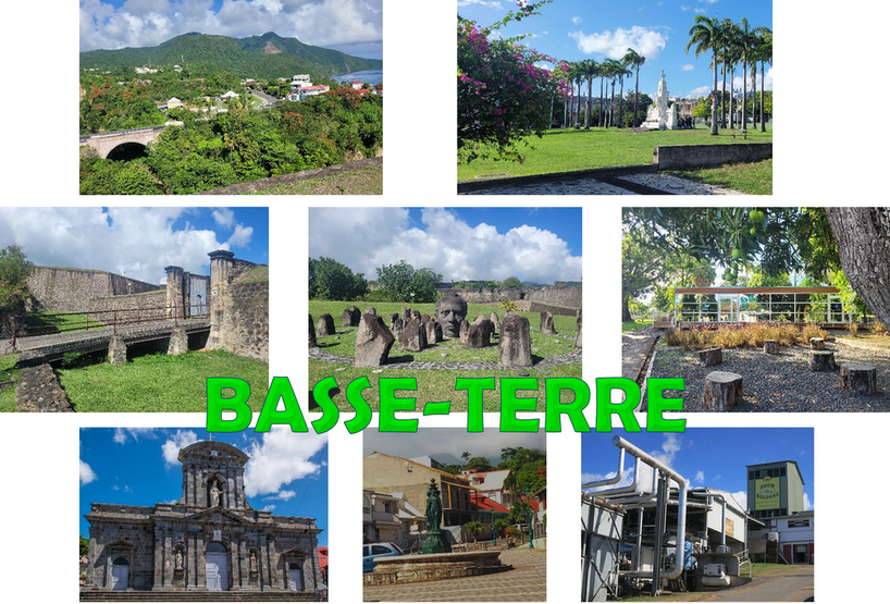
To learn more on Basse-Terre (Basse-Terre South)
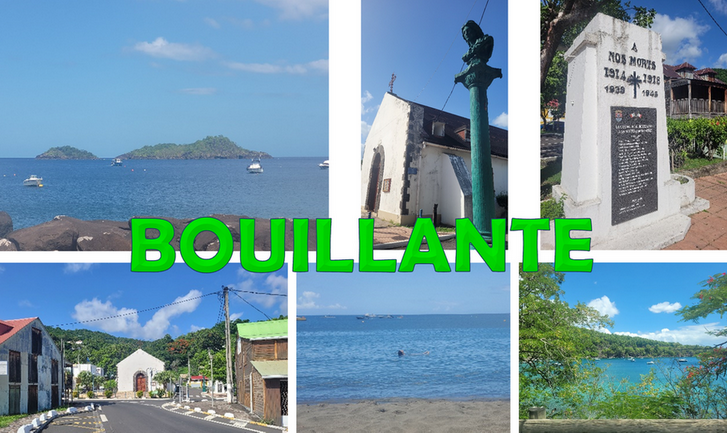
To learn more on Bouillante (Basse-Terre North)
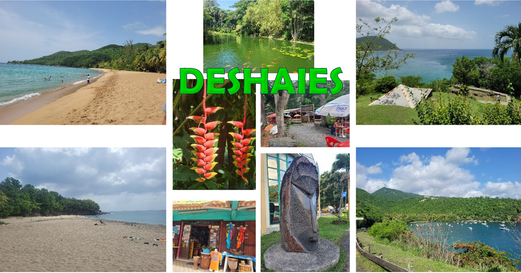
To learn more on Deshaies (Basse-Terre North)
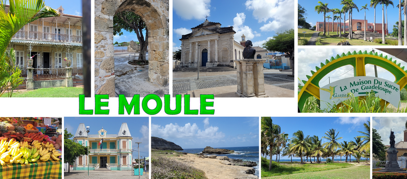
To learn more on Le Moule (Grande-Terre South)
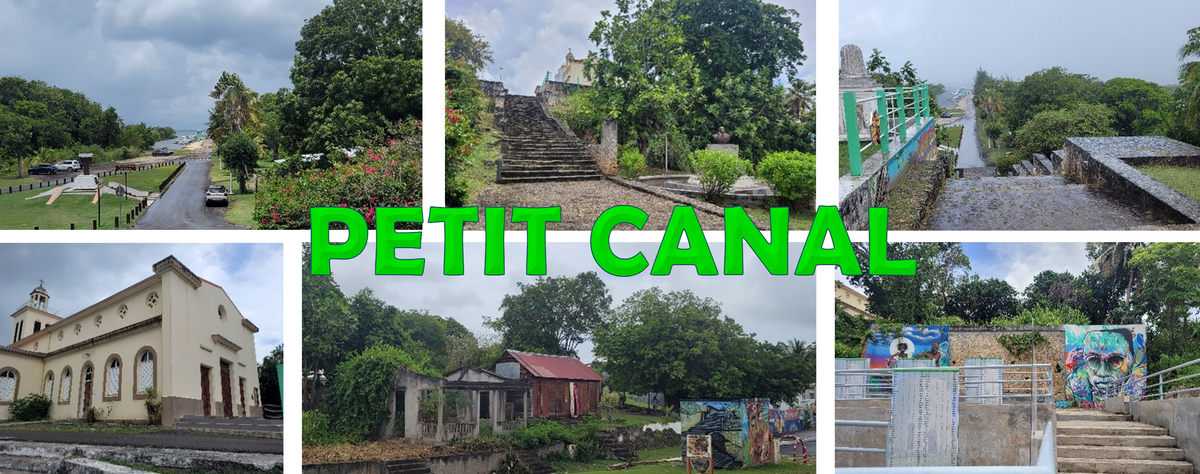
To learn more on Petit Canal (Grande-Terre South)
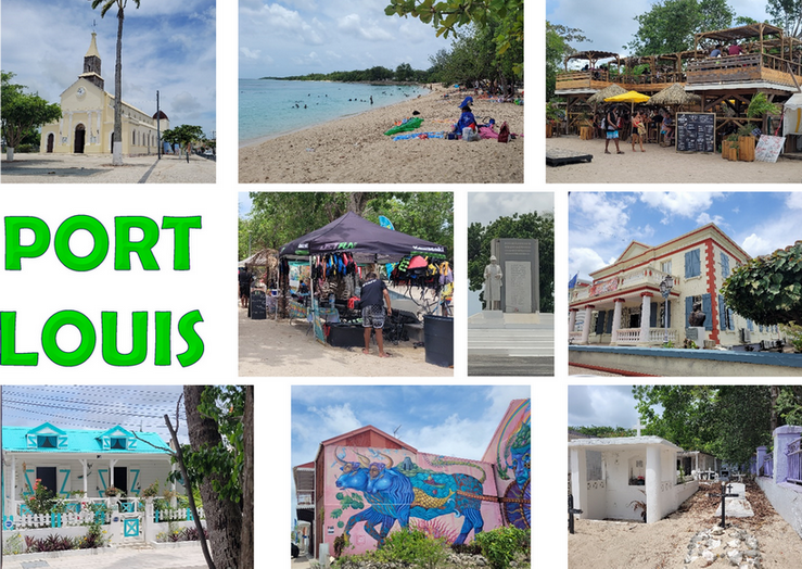
To learn more on Port-Louis (Grande-Terre South)
To learn more on Sainte-Anne (Grande-Terre South)
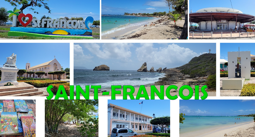
To learn more on Saint-François (Grande-Terre South)
To learn more on Sainte-Rose (Basse-Terre North)
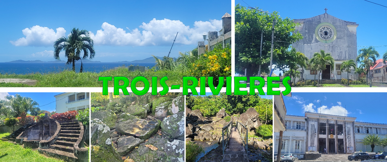
To learn more on Trois-Rivieres (Basse-Terre North)
