How sad, you have a family home, a house on the edge of the river with a view, fertile land, and under controlled and known agriculture and we advise that we must expropriate you. You finally had stability and what you built is taken away from you. No matter how, it must have been so frustrating.
Here, in Long Sault, several entire families had to move, out of necessity, to allow for a more efficient maritime passage, a major development project using the rapids for an electric dam and easier passage for large boats. Two villages were created, Long Sault and Ingleside, to accommodate over 6,500 residents of the villages of Milles Roches, Moulinette, Dickinson’s Landing, Wales, Farran’s Point, Aultsville and the hamlets of Woodlands, Santa Cruz and Maple Grove. It is the Canadian side that is the most affected by the loss of more than 8,000 hectares of land, redoing the road and even moving the rails of the railway.
The region, therefore, found itself in 1958 with a new territorial plan.
The construction of the dam has, therefore, created an overflow of water from the seaway. Villages were flooded and several small islands created. These islands are now connected by bridges to become the Long Sault Parkway.
At Upper Canada Village, there is one of the displaced houses and along Highway 2, the Lost Villages Museum.
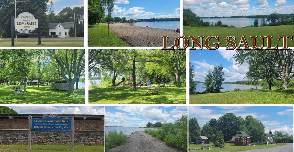
LONG SAULT PARKWAY
West of Cornwall, on Route 2, you can take a scenic drive called the Long Sault Parkway. Access is free but you pay to access the beaches or campsites. If you just decide to drive, you will pass by about ten islands. At the very end, you will reconnect to Highway 2 since it is a U-shaped route, both accesses to which are connected to the same highway.
Different stops are known for their beaches, campsites, picnic areas, scuba diving spots and more.
The ride was smooth. It was a change of scenery that we appreciated. No traffic, no stress, so we just walked around. However, it was too cold for a swim.
LOST VILLAGES MUSEUM
The museum is along Highway 2 and is a collection of typical buildings that once formed part of one of the villages: a church, a train station, a general store, a typical house, a barber shop and a school. We are reminded that the communities were tightly knit and that there was everything they needed, but that was broken up to make way for a plan for the future.
The museum on a small avenue is a reminder of the sacrifice of the inhabitants of its villages who sadly had to rebuild or recover in a new location.
UPPER CANADA VILLAGE
A popular place for schools, the Upper Canada Village allows you to live and therefore immerse yourself to better understand the history of colonization. We go back in time, to 1860, and the village of yesteryear makes visitors experience the walking context, the trades, the agriculture, the processing methods, the means of transport, the cuisine of the time and more.
BATTLE OF CRYSLER’S MEMORIAL
On an artificial hill stands a monument dedicated to the Battle of Crysler’s Farm which took place in November 1813.
LOYALIST MEMORIAL
At the same address is a monument unveiled by Queen Elizabeth II in 1959, the Loyalist Monument, which recognizes the contributions made by the early settlers of Upper Canada.
PIONEER MEMORIAL
During the voluntary flooding of certain villages in 1959, it was necessary to move several buildings and also cemeteries. Very delicate subject and meticulous work. Some tombstones of well-known locals have been moved to this place.
Other nearby places to visit:
- Cornwall, Ontario (15 minutes)
- Ruins of Saint-Raphael (30 min drive)
- Brockville, Ontario (1 hour drive)
- Ottawa, Ontario (1 hour drive)
- Montreal, Quebec (1h30min drive)